

MARSPLAN-BS II: Offshore Winds of Change in the Black Sea
In August 2016, the Government of Romania led by Dacian Ciolos adopted Ordinance No. 18 on Romania’s maritime spatial planning and based on this normative act a cadastre of the sea had to be made. It was all planned within the European project ‘Cross-Border Maritime Spatial Plan for the Black Sea – Bulgaria and Romania – MARSPLAN-BS II’, a large part of funding being provided by Brussels. Although five years have passed since the adoption of the ordinance, Romania is in the same place. It has not prepared such a plan, but instead is preparing to amend the legislation.
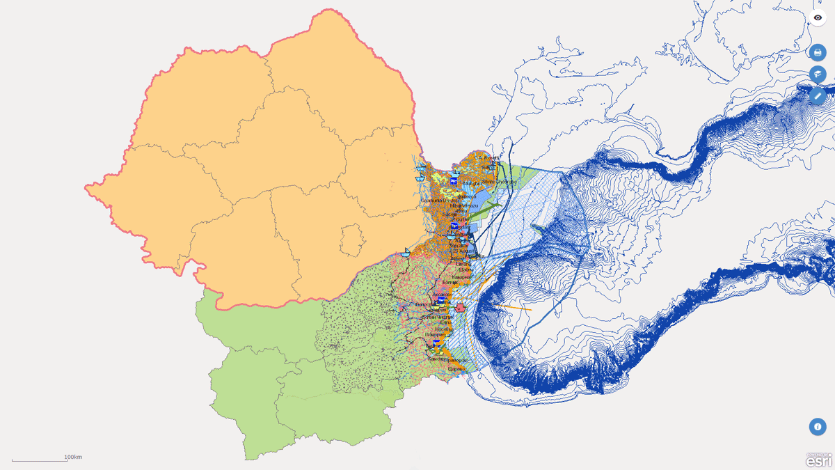
MARSPLAN – BS II, Bulgaria – Romania
The policies related to the protection and development of maritime activities in the oceans and the seas are on the top of the European policies agenda. The Black Sea is of strategic importance for security protection of this part of Europe and for the economic and social development of all Black Sea countries.
The Integrated Maritime Policy (IMP) is the most adequate approach for obtaining good environmental status of the marine area, as well as for most relevant investment environment for sustainable use of the potential of the sea including the creation of new jobs and sustainable ‘blue’ economic growth. Maritime Spatial Planning (MSP) is a public process for analysis and planning of human activities in marine areas to achieve ecological, economic, and social objectives. The final goal is to develop spatial plans which define the effective use of marine areas for different marine activities and sustainable use of marine and coastal resources. Thus, to create a framework for coordinated, transparent and sustainable decision making based on reliable data. Applying an ecosystem-based approach and the transboundary cooperation are of great importance for boosting the sustainable growth of marine and coastal economies.
Activities
The main activities are related to elaboration of the maritime spatial plans in Bulgaria and Romania with updated GIS model and database, based on the results of the first MARSPLAN-BS Project; develop the MSP common strategy for the cross-border area of Bulgaria and Romania, addressing also Land-Sea Interactions (LSI) and Multi-Use (MU) concept; provide effective stakeholder participation in the design of national and cross-border MSP process and sharing of good practices for the Black Sea from Bulgaria and Romania.
Main project objectives
- To support the coherent, cross-sectoral Maritime Spatial Planning (MSP) in Bulgaria and Romania under the framework of MSP Directive 2014/89/EU and to establish a long-lasting mechanism for the Black Sea Basin cross-border cooperation on MSP.
- To help capacity building and supporting Competent Authorities in Bulgaria and Romania for MSP implementation, as well developing of national marine spatial plans on the bases of results of the first MARSPLAN-BS Project (2015-2018).


Romania sits idly by
Although no deadlines were imposed at the level of the European Commission for making this plan, Romania managed not to move anything for its accomplishment. In December 2020, the Ministry of Public Works, Development and Administration put up for tender the contract for “purchasing expert services for substantiating and preparing the Maritime Spatial Plan”. According to the notice posted at the time on SEAP, the subject matter of the contract is conclusion of a contract, in order to purchase expert services for substantiating and preparing the Maritime Spatial Plan, in accordance with the provisions of the Directive 2014/89/EU of the European Parliament and of the Council of 23 July 2014 establishing a framework for maritime spatial planning and Government Ordinance No. 18/2016 on maritime spatial planning, within the project ‘Cross-Border Maritime Spatial Plan for the Black Sea – Bulgaria and Romania – MARSPLAN-BS II’.
The contract, with an estimated value of RON 1.2mln, VAT excluded, was not concluded, because in April this year (2021) the tender was cancelled.
Although almost four months have passed, no tender took place since then.
Why amending the legislation
The amendment and supplementation of Ordinance 18/2018 under the draft currently put up for public debate by the Ministry of Development aim only at issues meant to ensure the operation of the Maritime Spatial Planning Committee, an inter-ministerial body that ensures the development and monitoring of implementation of the Maritime Spatial Plan, i.e., precisely that body that so far has not done anything. It operates under Prime Minister’s coordination, who also ensures its chairmanship. One of the most important amendments that envisages the operation of the Committee refers to eliminating the wording ‘nominal membership’, so that the persons nominated by the component institutions are not established by Government Decision, thus avoiding the blockages generated by the need to amend it for each change of nominations. Basically, the wide representation of ministries in this Committee, to which several regulatory authorities are added, turns it into a mini government.
What should the marine cadastre provide
The primary purpose of maritime spatial planning consists of promoting sustainable development and identifying ways to use the maritime space for various purposes, including for managing conflicts in marine areas.
Specifically, MARSPLAN-BS would have a guiding and regulatory character for activities in aquaculture areas, fishing areas, facilities, and infrastructure for the exploration of oil, gas, and other energy sources, of mineral resources, and to produce energy from renewable sources.
It would also cover maritime transport routes and traffic flows, military exercise, and training areas, protected natural areas in the national network, scientific research, including related facilities and infrastructure, submarine cable and pipeline routes, and their safety and protection zones.
Last but not least, the plan would include references to areas with tourist activities, with underwater cultural heritage, coastal protection measures against erosion, intervention plans in case of accidental pollution or in case of a marine natural hazard at risk for the coastal area and areas where there is port and hydrotechnical infrastructure.
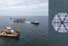
Wind potential of the Black Sea
Once Romania has a plan for maritime spatial planning, the country will be able to attract very large investments by exploiting the wind potential of the Black Sea. On the other hand, the apparition of offshore wind farms will have a positive impact on Romania’s energy independence, the authorities claim. According to a study conducted by the World Bank specifically for the Black Sea area, in the coastal waters area alone Romania has the possibility to set up wind farms with a potential capacity of up to 72,000 MW. Romania has the best continental shelf for wind energy in Europe. It is very stable from a tectonic point of view and allows the installation of wind turbines even at only five meters in the ground. Wind would also allow them to produce energy seven to eight months a year, while in other similar regions wind turbines produce only five to six months a year.
Who leases the land under water?
Developing the maritime spatial plan wouldn’t be the only problem that authorities should solve to green-light investors to build wind farms in the Black Sea. In Romania it is unknown what is the institution that should lease areas or land in the Black Sea for this type of activity to companies, specifically who will be able to manage the territory below the sea surface.
For now, the issue is being analysed by the Secretariat General of the Government, an analysis being ordered to this end.